


THREE CREEKS Voting District, Union County, Arkansas
About
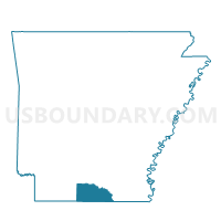
Outline

Summary
| Unique Area Identifier | 528274 |
| Name | THREE CREEKS Voting District |
| County | Union County |
| State | Arkansas |
| Area (square miles) | 54.17 |
| Land Area (square miles) | 54.15 |
| Water Area (square miles) | 0.02 |
| % of Land Area | 99.96 |
| % of Water Area | 0.04 |
| Latitude of the Internal Point | 33.11311960 |
| Longtitude of the Internal Point | -92.85885090 |
Maps


Graphs
Select a template below for downloading or customizing gragh for THREE CREEKS Voting District, Union County, Arkansas


Neighbors
Neighoring Voting District (by Name) Neighboring Voting District on the Map
- EL DORADO COUNTRY BOX 4 Voting District, Union County, AR
- JUNCTION CITY COUNTRY BOX Voting District, Union County, AR
- LISBON Voting District, Union County, AR
- NEW HOPE Voting District, Union County, AR
- Precinct 1, Claiborne Parish, LA
- WESSON Voting District, Union County, AR
- WOOLEYS STORE Voting District, Union County, AR
Top 10 Neighboring County Subdivision (by Population) Neighboring County Subdivision on the Map
- El Dorado township, Union County, AR (26,219)
- District 1, Claiborne Parish, LA (1,514)
- Henderson township, Union County, AR (739)
- Van Buren township, Union County, AR (659)
- Cornie township, Union County, AR (488)
- Wesson township, Union County, AR (394)
- Garner township, Union County, AR (348)
- Tubal township, Union County, AR (282)
Top 10 Neighboring Unified School District (by Population) Neighboring Unified School District on the Map
- El Dorado School District, AR (26,332)
- Claiborne Parish School District, LA (17,195)
- Smackover School District, AR (4,267)
- Junction City School District, AR (3,128)
- Parkers Chapel School District, AR (2,825)
Top 10 Neighboring State Legislative District Lower Chamber (by Population) Neighboring State Legislative District Lower Chamber on the Map
- State House District 11, LA (42,174)
- State House District 7, AR (26,507)
- State House District 6, AR (25,251)